Wednesday, May 25, 2011

Spring in the Methow

So, right after the Grad retreat Scott, Laura & I loaded into the van and made the 7 hour drive over to Twisp. Typically, this would be a 2.5 hour drive (max) but since the pass was and is still closed, we had to go ALL THE WAY AROUND. At least it was sunny out.
The great thing about the Methow is that it's a desert/brush landscape due to the lack of annual rainfall. But, low & behold, it rained and POURED the entire weekend. We watched the river come up nearly 2 feet in a 30 hour period of time. Spring in the methow turned into rain in the Methow... however, we survived. NCI puts on adult field classes, and the focus of this class was to explore the varied vegetation that blooms in the Methow in Spring as well as the migratory birds that call the Methow home for a few weeks each year. There was only one issue. This area of Washington is about a month behind this year due to the long and cold winter we have had... so, all of the plants that typically would be blooming right meow, are instead a small sprout in the ground... and all the birds that typically fly around catching insects and feeding on nectar were hiding due to the rain.

yet, we persevered and experienced our own spring in the Methow.

Wolf Lichen on a Ponderosa

We had a slide show one night in an art gallery. I saw this artists work this past spring and fell in love with it, and was happy to see it again

SPRING!

Pipe Stone Canyon

More of Pipestone Canyon

Tuesday, May 24, 2011

Farm hands

The last day of our grad retreat found us at Blue Heron farm, located in Rockport. Blue Heron is this amazing farm run by two amazing people that have a contagious enthusiasm for the environment, sustainable agriculture, community farming and the national park. So, Friday morning we all found ourselves wrist deep in fertile organic soil planting various onions that will later be sold at the Skagit Co-op and served at the ELC.

Horse Kisses!

The Fruits (or onions) of our labor!

Grads hard at work

Plants hanging out in the green house

A very feisty rooster

I had a great time and can't wait to go back to the farm again! It was such an amazing experience to plant our own food and recognize the importance of using pesticide free chemicals to ensure that we're putting the healthiest things into our bodies.

Monday, May 23, 2011

Catch-up

So, i've been kinda MIA lately due to a lot of different mini-events that all occurred at the same time. So, i'm going to play catch-up with this blog and fill you in with where i've been over the past few posts.

Grad Retreat!

Each quarter we venture out and go explore some "new" location. For this retreat, we decided to stay a little more local and paddled toward Thunder Arm, which is on Diablo Lake. Typically, this wouldn't be that difficult since it might be 3 miles away (im giving it the benefit of a doubt). However, on this fine day, a storm was settling into our lake with gusts i'm guessing reached around 50 mph, and a pretty fine dousing of rain. Luckily, when we set out paddling, the wind was only around 10 - 20 mph, so no capsizing... but definitely some interesting paddle techniques were utilized. We would raft up on the leeward sides of islands, take a breather and then paddle on.


After we reached our campground, we promptly set-up our tents and went out to explore. Teresa, Tanya, Codi & I ventured toward the highest point on our little peninsula, and found ourselves hanging onto dear life. The wind had seriously picked up and we were all doing our best to not get blown over.


Then the rain started. I'm usually a fair sport for hanging out in tents in the rain. Today I was not. So, I proposed that we start drinking (it was maybe 3pm)... and drink we did.


By the time the rain and wind let-up, we were all on a solid path to getting hammered... and didn't even really notice that we could venture outside of our covered picnic table. We quickly made dinner... told stories and passed out.

We all woke up the next morning to clear and calm skies! Codi, Teresa & I loaded into the canoe, and traveled further up Thunder Arm where we encountered tree swallows, violet green swallows, golden eyes, mallards and snow capped mountains. It was such a beautiful morning that I couldn't ask for more.


Sunday, May 22, 2011

tiny people. big mountain

Taken from "North Cascades Geology"

Mount Baker is one of the youngest members of the Cascade Volcanic Arc. It is probably less than 30,000 years old and has not been eroded enough to expose its granitic roots. The most conspicuous young lavas associated with the volcano flowed down Sulphur Creek less than 10,000 years ago, erupting from a small cinder cone near Schriebers Meadow. An explosive eruption of steam blew out of Sherman crater, near the summit of Mount Baker in 1843, and steam still hisses into the sky from vents around the rim. We have every reason to expect future eruptions from Mount Baker.

On Thursday morning, we woke up at 3:19am, and began shuffling around the house. Thankfully I laid my clothes out the night before, so I was 51% sure that I was putting the right clothes on. I downed a bowl of oatmeal and we loaded into the car. We bid adieu to Chris & Linden who stayed the night and were heading out the door toward Shuksan.

We picked Chris up at 3:45am and started the drive on 542 toward Glacier Creek rd. The moon was nearly full and the sky was perfectly clear. We could see the outline of peaks pass by as we zoomed down the road toward our destination. At 5am we started the snowmobile and drove up Glacier Creek road for about 2 miles until we reached the trailhead. The sun had not risen, but dawn was upon us and the sun was filled with pale blues, yellows & oranges. We started skinning at 5:30am.

We made good time and reached the summit at noon. I opened my bag of cookies and enjoyed the views of the North Cascades, Olympics, Rainier and Canada. The video below includes some photos that Frankie took as well as path up to the summit.


Share your Adventures with SpotAdventures

Wednesday, May 11, 2011

gone paddlin'

so, im about to head off on a 5 day naturalizing adventure... the first 2.5 days around the ELC, and then the next 2.5 days out in Twisp... so i will be incommunicado. BUT, to tide you over while i'm gone... here are some photos from my trail run to Big Beaver yesterday. Ross lake is around 95' below average right now. (WHOA) so i had to go check it out for myself. 14 miles later i was back at the car and exhausted.

but it was worth it.


looking north toward Hozomeen & Desolation


it's a long boat haul from the shore to the dock!


Jack Mountain in the distance


Waterfalls can be seen again in their natural form with the water level so low. Typically this is all covered by the lake


Trail runners paradise!

Monday, May 9, 2011

Adventure!!

I was itching to go exploring this weekend, so I chose to go to Vancouver Island and check it out. My plan seemed flawless. Get up early and drive to Tsawwassen where the ferries leave out of Vancouver and travel through the Gulf Islands and arrive to Vancouver Island an hour & a 1/2 later. So far, the adventure was going well. It was pouring rain on the coast, but the second I got on the ferry, the skies opened up and the sun filtered down. The rest of the day would be filled with sun with clouds floating by from time to time.

Once arriving at Swartz Bay, I immediately started pedaling and stopped 5 minutes later at a gigantic map. I had no clue where I was going. I stupidly assumed that there would be signs everywhere telling me how to get to Butchart Gardens or to Victoria... and well there was... if i wanted to bike on a 4 lane highway. Which I also found bizarre. I thought Vancouver Island was going to be filled with farms and gigantic tree's. Instead, it was a mixture between Bainbridge Island and Ottawa. Weird. Anyway, at the map, these really nice Canadians helped me out by finding their GPS at the bottom of a gigantic rubbermaid tub, and then plotted the coordinates to Butchart Gardens. They also suggested I take a more scenic ride and take my time getting to the Gardens. I agreed.


View Vancouver Island in a larger map

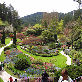
I set out from Swartz Bay and traveled on Lands End road, which skirted the coast, and then began my travels south on windy back roads. About 1.5 hours later, I found myself at Butchart Gardens. I also found myself pedaling on a bike where the seat post was about 1.5 inches too short. I didn't have an allen key with me, so i just sucked it up for the first part of the ride. After paying $30 i entered the gardens which were amazingly beautiful and well manicured. I was expecting them to be quite large due to the hefty entry price, but I was finished walking the grounds after a very slow 2 hour walk. And let me be perfectly clear. I took my sweet time. I even sat on benches. If you know me, you know I am not a bench person. I tried to drag my $30 out as long as possible.


Tulips for days


i really got into using the macro function on my camera this time


Fiddle heads!


Sunken Gardens


more tulips


After I could not take it any longer, I decided I would head south toward Victoria. I promptly found a gas station that let me borrow a #5 allen key, and i fixed my seat. (THANK YOU!!!) this made biking significantly easier and way more efficient. If I was smart, I would've asked for a map or directions as well. But instead, the adventure continued and i just biked in various directions with the overall goal of heading south. I found myself on side roads, main roads, bike paths, gravel paths and a hiking trail. It was definitely an adventure. I got to a point while i was on the hiking trail that this was completely ridiculous, so I just found the closest street, headed east toward the highway, and found a major road that took me straight to Victoria. I was really surprised with the amount of suburban sprawl that existed on the outskirts of the city. I also was expecting it to be a quiet little old english city on the islands coast. I mean, they serve high-tea! Instead, I felt like i was in a metropolitan area with some old buildings. So, i just bee-lined it to the visitors info desk, asked where i could catch a bus to get back to the ferry, bought a milk shake and walked my bike to the bus stop. I had no desire to experience the tourism delight of Victoria, and I am glad I left when I did. I made it back to the ferry dock just in time to make the 5pm ferry.

I think the ferry was by far the highlight of my journey. It was a pretty large size ferry, larger then any washington ferry I've been on. They have two upper decks that are dedicated solely to passengers, and they are very nicely done. I found myself sitting up on the 6th deck in the main passenger area that probably seats about 200 people, when they piped in the Canucks Hockey game on all tvs and speakers on the ship. Talk about a full canadian experience. Everyone whooped and hollered as the Canucks scored a goal and gasped as Nashville would score a goal. It was pretty amazing.


Gulf Islands!


Another ferry passing by


just another day on a ferry


I got back to Bellingham around 8pm. 13 hours after I left. I deem adventure day successful. Over 40 miles on my bike and some great flower and watching as well as great ferry time.

Thursday, May 5, 2011

buzzzzzzzed

So, we have a resident hummingbird. A Rufous Hummingbird to be precised. This little guy just buzzes around, peeks into windows and sucks nectar from the few plants that are actually flowering up here. In an effort to learn more about our native creatures, or visitors in some cases I thought I would do some research.

First - here's a photo (which i did not take)


This bird is obviously all business. It's known for being one of the more feisty birds out there, and will try to attack larger birds that are in the way of sweet flowers!

When it is in aggressive mode, it will flash this bright orange patch (if its a male) on its throat, which slightly mesmerizes you.

I wont bore you with all of the fun facts that I found... such as they can be found in alpine meadows at 12,600' in elevation (what?!?!?) or that they have the longest migration of any bird based on their body length (they are 3 inches, and travel 74,700,000 lengths, while the bird with the longest physical migration, only travels 51,000,000 lengths.)

This bird is pretty awesome. But what is even better are the noises it makes!

You will need to go here to listen : http://www.allaboutbirds.org/guide/Rufous_Hummingbird/sounds

my favorite sound was "Calls made at reflection in window"

priceless.

Wednesday, May 4, 2011

for the love of running

I have a few goals in mind for this summer, all which require me to be able to run and to run far. I live in a beautiful place where access to mountain tops or glacial valleys is only by paddle or 2 feet. So, training for my summer officially started yesterday. I worked with 4 other ladies up at the ELC to craft a training plan for the next 14 weeks that would ultimately allow us to run to the top of Cascade Pass


Then down to the Stehekin River valley where we will sleep for the night.


Then run out the following day on the PCT from High Bridge camp to Rainy Pass

It will be around 17 miles a day with some significant elevation gain and loss.

Which is why training started yesterday. Thankfully, it's really not that hard to get motivated to go "training" here when amazing trail running surrounds you at every instant. From my back door i can run 3.5 miles (RT) up to a waterfall, or 7 miles (RT) along cliffs overlooking Diablo to turn around at Ross Dam. If i drive for 5 minutes, I will end up at Colonial Campground where the running is endless.

I can run to the top of Thunder Knob


Or to the top of 4th of July Pass

Or to Easy Pass


Or the ultimate run to Park Creek Pass

The options are limitless with runs to Big Beaver, or up and over Whatcom Pass to highway 542 and on and on and on.

So, my 8 mile trail run through the woods up Thunder Creek yesterday was filled with excitement as I knew that every step I took would get me that much closer to amazing trips this summer.


*note - none of these photos are mine. so, thanks google!

Monday, May 2, 2011

searching for snow

For quite a few weeks I have had the goal of pedaling from the road closure gate on highway 20 (mile post 134ish) to the snow wall. If you haven't been following the updates on highway 20 this year, here's a quick synopsis. WASHDOT begins plowing the highway once the snow has ceased to fall and avy danger has subsided throughout the region... and this typically occurs in March. However, this year, WASHDOT was still plowing highway 2 (Stevens Pass) well into the first part of April and still doing avy control, with another slide occurring just last week! So, to say the least, they're getting off to a late start with clearing hwy 20 this year. Typically the pass is open by now, but this year it will be a lucky day if it opens before Memorial day - the latest opening since the highway opened in 1972!

So, when WADHDOT begins to clear the road they dispatch a team on the east side and a team on the west side to begin clearing, with the goal that they will meet in the "middle." The east side team has been stuck around milepost 167 clearing out all of the avalanche debris left around the Washington Pass area. In one spot it is recorded that snow depth is at 65 feet due to a massive slide. The westside team made it to about 152ish, but rumors abounded that they had actually plowed to 155. I have been trying to bike to the snow wall, where the west side crew had stopped plowing for about 3 weeks now... however, the fact that I have been on a bike about 2 times since October really was not weighing in my favor. So, the first 2 times I tried biking to the snow, my legs just wouldn't let me pedal forward as well as some time constraints.

BUT Sunday was different. I had no time limit, a partner that was convinced this was a good idea and blue skies with temps hovering in the high 60's! It was time to go.

So, imagine yourself pedaling on a road with incredibly smooth asphalt with no cars to be found. The only sounds you hear are the wind moving through the trees and your own breathing. The only things that you see on the road are 6 other bikers and hundreds of butterflies. The first 4 miles are a rolly up and down hill with a beautiful overlook of Ross Lake.


From the overlook you could see Hozomeen and Desolation in the distance. Ross Lake is reported to be approximately 95 feet below it's average height. Seattle City Light lowers the lake throughout the winter and spring in expectation of the spring melt, which will flood the lake if precautions are not taken. However, this year, the spring melt might come in summer at the rate we're going.

After spending some time at the overlook (milepost 136ish) we began our journey up. You might never realize it in your car, but you are magically transported from an elevation of around 2100 feet to nearly 4600' at Washington Pass. This becomes much more apparent when you are cycling. Thankfully, the elevation gain of over 2000' for this ride, is marked by spectacular scenery that seems almost magical. Jagged snow-capped peaks dot the skyline while waterfalls ripple down the rock faces of nearby cliffs. The walls of snow on either side of the highway begin to grow as you continue to pedal up in elevation.


Finally after pedaling for about an hour and a half, we reached a beast sitting in the road, which also marked the end of a good plowed road.


Zach decided to conquer the snow beast


We tried to pedal for another mile, but there was still snow and ice on the road, and it just did not seem safe. Returning to the green monster we deemed our trip successful. We then turned our bikes around and enjoyed 2000' feet of downhill riding for the next 15 miles. I do not have a speedometer on my bike, but I can assure you that I was going fast enough that tears were flowing from my eyes from the wind. We crossed the Panther Creek Bridge, where we had our last uphill battle - 400' elevation gain to the lookout. Not that much of a climb, unless you just spent the past 1.5 hours climbing. However, it did go by quickly, since you could turn your head slightly to the right, and zone out while looking at the Picket Range in the far distance.

We arrived back at the car a little over 2 1/4 hours later. We snacked and reflected on the ride. This is by far my favorite road ride, and I secretly hope the road stays closed just a little bit longer so I can continue to have my own private highway.